Professor Ian Ralston
Projects

A trench, initially some 8m long by 4m wide, was laid out in the garden SW of the rear wall of the house at The Brae. After the removal of topsoil, a drystone structure covered with rotting timbers was located and identified as a soakaway associated with the Brae (built in 1912) (Fig 8). Sondages demonstrated that there was a considerable build-up of made ground here and the area of excavation was thus reduced. Towards the northern end of the trench, subsoil was reached at a depth of approximately 1.7 m, with all the overlying layers containing localised building rubble, as well as modern glass and pottery. At the SE end of the trench, modern deposits reached a thickness of 2.8 m and the area examined was reduced and steps introduced as a safety measure.
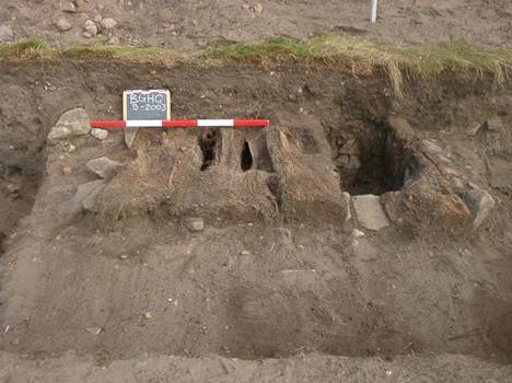
Fig 8 Rotting timbers and the top of the walls of the soakaway in made ground in the garden to the SW of The Brae
Below the built stone wall of the former soakaway, a small area of tumbled sandstone slabs was identified spilling over a small patch of a laid surface of small flat sandstones and water-rolled cobbles (Figs 9 – 12). To the SE, this ended against a cut down into a ditch, the full dimensions of which could not be investigated because of the proximityof the wall, in poor condition, that stood between the NW and central gardens of the Brae. The ditch fills were relatively unconsolidated and again contained (to the depths reached) an admixture of modern detritus: pending further work, which would be necessary to confirm the hypothesis, given the very restricted area investigated, it is hypothesised that this ditch, running obliquely up the slope through the garden of the Brae, is probably the central one of the three shown by Roy at the end of the eighteenth century and infilled thereafter, latterly in the laying out of the terraced garden of the Brae.
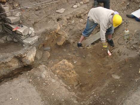
Fig 9 Initial signs of the features beneath the soakaway in the NW garden at The Brae. The paintbrushes rest on the SE wall of the soakway; the pitches sandstone blocks in the section to the SE of this are believed to derive from the original bank. Cleaning of the area of small flat stones and cobbles is in progress.
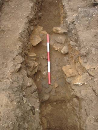
Fig10 The NW garden at the Brae: looking NW and showing the exposure of the ditch cut, the area of cobbling and the tumbled sandstones (Scale 1m by 0.2 m divisions).
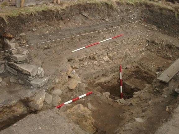
Fig 11 The ditch and other features to the SW of The Brae at the end of the excavation, looking NE. To the left is the soakaway wall, with the inclined sandstones of the putative tumbled face below it; the 1m ranging pole lies of the cobbled surface; the other metre pole stands upright at the lowest point reached in the sitch; the steps in the ditch fill on the right are artificial cuts below the standing garden wall.
Not enough could be investigated to clarify the character of the bank adjacent to the ditch, which had been severely damaged at the time the stone-built soakaway was inserted. The nature of the tumbled sandstone however suggested that this may have originated from a dry-stone revetment or facing to the bank at this position.
Associated with the cobbling and sealed below the tumbled stonework of the putative revetment was a thin lightly-organic-stained horizon, some 1-2 cm thick. This was sampled by Dr Mike Cressey with the hope that it might prove analogous to other organic horizons found sealed elsewhere beneath the enclosing walls of Burghead e.g. by Edwards and Ralston in recutting one of Alan Small’s interventions and latterly, and much more massively, by Johnson and Cressey at the position of the former coastguard lookout on the middle wall at the apex of the promontory. Samples were examined from this context and prepared for pollen analysis by Dr Cressey, but they proved not to be polleniferous.
At this stage, work was abandoned, given the proximity of the standing wall and the trench was backfilled. A tentative agreement was reached with the owner, Mr Gilbert Fraser, that further excavations could take place here to allow both the bank and ditch to be examined more fully, but that these needed to await firstly, the demolition of the wall between the NW and central gardens of the Brae and, secondly, the consolidation and stabilisation e.g. by underpinning of The Brae itself. Further discussion with Mr Gilbert Fraser suggests that these procedures may happen in 2006.
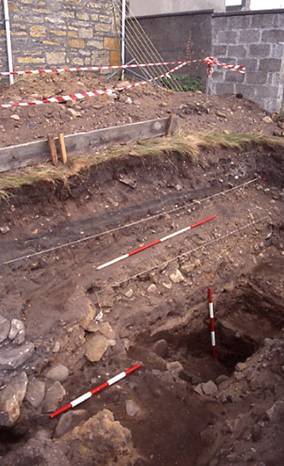
Fig 12 The ditch in relation to the SE corner of the rear wall of the Brae, and the breeze-block diving wall between the NW and central gardens. The ditch runs obliquely up slope to the NE and is likely to continue under the lean-to garage and Grant Street before becoming apparent again in the cemetery of St Aethan’s.
It was subsequently noted that the trace of two of the banks marked by Roy and their accompanying ditches can be appreciated obliquely traversing St Aethan’s graveyard. The clearest indication is provided by the angle of inclination of several of the gravestones (Figs 13 and 14). An effort was made to map these slight banks by detailed contour survey amongst the gravestones, but this was not done at a sufficiently fine scale to enable the banks satisfactorily to be mapped. Meantime, the best evidence for these banks is photographic.
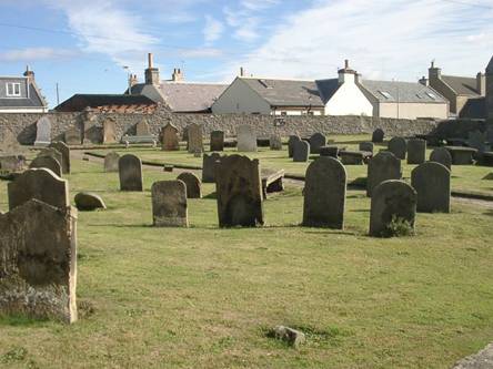
Figure 13 One of the slight banks apparent in St Aethan’s churchyard can be seen owing to the angles at which the middle two of the row of four gravestones stand.
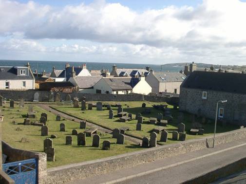
Fig 14 Oblique view from the attic skylight in The Brae. The slight central bank and two hollows corresponding to ditches in the gardens of the Brae.
It can also be argued that the former alignment of elements of the system of outworks across the Burghead headland can be traced in selected signs of minor settlement in certain present-day buildings that sit approximately over the alignment of the former ditches but, given the sensitivity of this issue, it is not reported further here.